Virtual Field Trips using Google Earth/Maps
Fieldwork is a central component of the Geography curriculum, and is pedagogically useful as a chance for students to ‘see’ things that are described and discussed in text and on slides.
I wanted to provide, on my three courses, remote options for fieldwork for students with any accessibility challenges and for sites for which we did not have the budget or the time to access (California in the case of GEOG21512) and for use during the remote working in the COVID-19 pandemic for all students. The rationale of virtual fieldtrips is for students to visualise real-world geomorphological features in a virtual setting, when there is restrictions to access to the outside world.
Google Earth/Maps offered a solution as a platform for virtual fieldtrips. Because it is important to also provide some guided self-exploration as well as illustrate examples, this involved embedding stops on Google Earth each with additional resources, such as photographs, and a series of prompts about things to think about. For example, in GEOG21512 the virtual fieldtrip included handouts for guidance, and the tasks were assessed as a small-weighted component of their coursework grade. e.g. Aeolian (1 of 3 components). Click here to launch the Aeolian fieldtrip in Google Earth
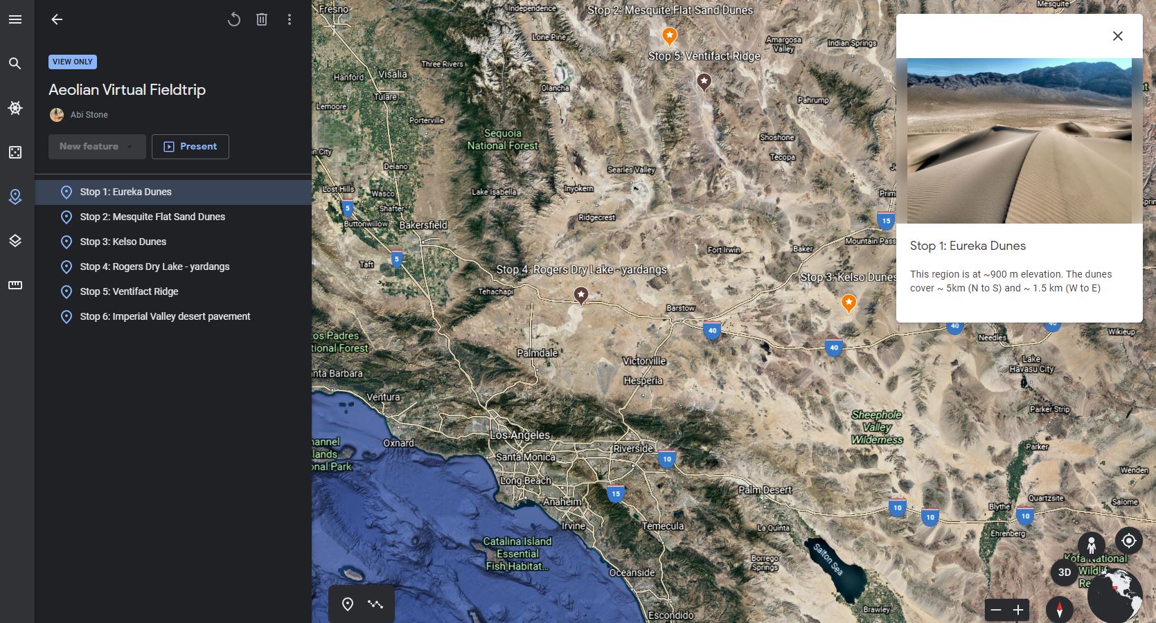
Aeolian Virtual Fieldtrip
For GEOG30531/60531 the fieldclass supported an assessment, with datasets made available to all students (including those only attending remotely).
Click here to launch the Formby fieldtrip in Google Earth
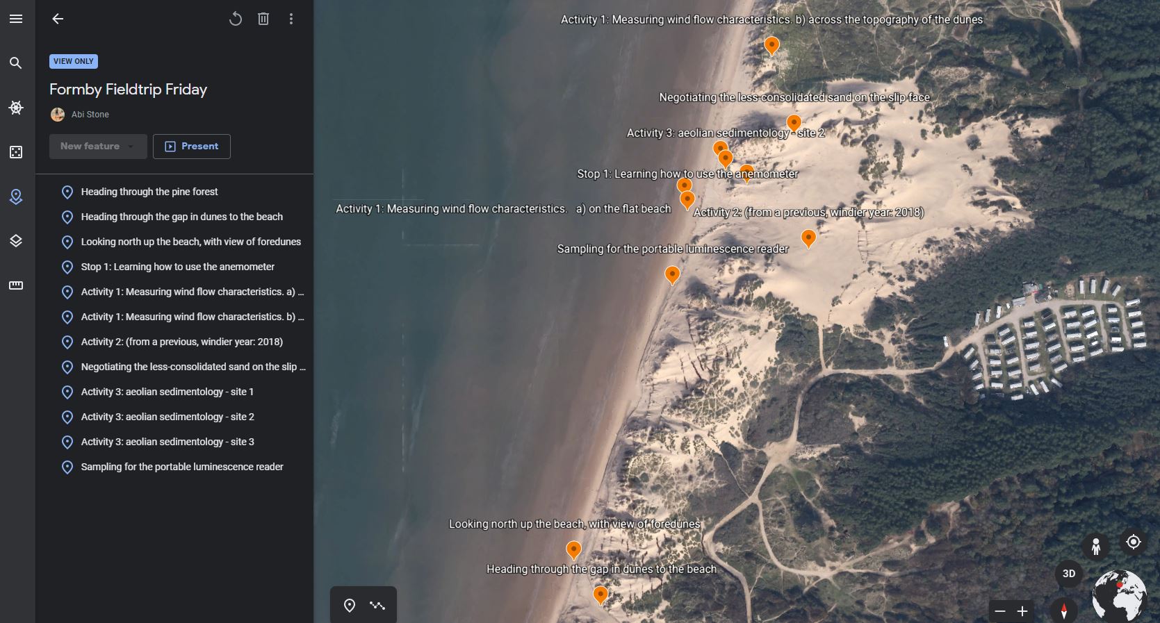
Formby fieldtrip
For GEOG20072 the virtual trip involved providing the background and giving pointers to help students design a research project that would be undertaken at some of the sites. See two resource examples:
- Overall trip: Pyrenees and Ebro Basin (Google Earth)
- To guide the research projects: Aragon Valley (Google Earth)
In terms of impact and benefits so far, GEOG21512 virtual fieldtrip has run since 2018, making the most of the Californian landscape without the time and budget to go overseas. The students have engaged well and complete the accompanying assessment. Students perform well in this assessment (with averages around 10% higher than for standard coursework essays, demonstrating their engagement with the activity).
In the case of GEOG30531/60531 an injured student and a student joining the course late were both able to use the resource to gain an insight into the field activities, which allowed them to complete the coursework assignment.
GEOG20072 has only run once. Students have incorporated screenshots from the fieldcourse in their research project write ups to good effect, demonstrating engagement with the resource and suggesting that they have found this useful.
I would be very happy to use this format again. Moving forward, it may be potentially useful to explore new functionality such as (1) including video snippets and (2) providing an element of interaction (live feedback) from students too.
Evaluation / Student Feedback
End of Unit Questionnaires for GEOG21512
2018-19
“I enjoyed the virtual field trip, was different to anything else I have done since being at university”
“I really liked the virtual fieldtrip as we got to remotely engage with different geomorphology and it is really helpful to see things in action. Also, I really liked the experience of GoogleEarth.”
2020-21
“The Virtual fieldtrip worked really well – I really enjoyed this, was different to all other units and a short and snappy way to consolidate knowledge”
Additional emailed feedback (student in 2019-20 cohort)
“I thoroughly enjoyed the GEOG21512 Geomorphology course, especially the virtual field trip using Google Earth Pro. This was an excellent addition to the course allowing us to visualise the geomorphologies we had been studying. This enabled us to gain an appreciation of the scale of the landforms under study without leaving the comfort of our desks. This really aided my understanding of the landforms themselves and the erosional and depositional processes that form them, especially as these features are often so large or hidden, they can not be easily seen in the field. This was further helped by the guided question sheets which focussed our attention on interesting aspects of the landscapes we were looking at. This was very helpful when coming to revise as I had a document of questions and answers surrounding the course material and also a greater understanding of the topic of study itself.
“Using Google Earth Pro was also an excellent introduction to using remote sensing techniques in field work. In fact, this course taught me skills that I used in the data collection for my dissertation. Without this course, I would have struggled to collect data due to COVID restrictions around primary data collection in the field. Furthermore, the methods and ideas introduced in this course surrounding remote sensing have been built upon in the GIS modules of my masters. This virtual fieldwork and the skills obtained from it have put me in good stead for further study.”
GEOG30531 (joint GEGO60531)
Student 1:
“Overall, I think the Google Earth Resource was incredibly beneficial. I was worried about missing the field trip as I thought I would be disadvantaged, but the resource really benefitted me. Firstly the resource was very easy to follow and understand as the activities for the day were labelled on the left and the location of each site on the right. Additionally, each site was accompanied with a range of photographs taken on the day and descriptions of activities so I was able to visualise the day and understand the activities. This was very helpful in the actual coursework too, especially when annotating field sketches and imagining the consolidation of the dunes. I also found the resource useful when understanding how all of the equipment worked because detailed instructions were given alongside photographs. I think this is very important as I would now feel confident carrying out research using such equipment on my own. Personally, I found the photographs most helpful as I could visualise myself at the sites, almost as if I was there!”
Student 2:
“The clear presentation of the minute details of the trip in the order of their occurrence, made the resource a joy to browse for me. Apart from going through the information about each activity on the map I could also browse through geotagged pictures clicked by the onsite team which I felt was fantastic. I really appreciate the level of effort put into making this resource and would like to thank you for enabling this virtual trip for me.”
GEOG20072
The fieldwork component is one part of a wider compulsory course for 2nd year undergraduate students, and unit feedback was very low.
The positive outcomes were seen in other ways. Around 30% of students used screenshots from the virtual fieldtrip in their project write ups, demonstrating their deep engagement with the materials.
Benefits
The expected benefits were to offer an insight into something we could not access physically and learn from the virtual visualisation of landscapes.
The actual benefits were that student learning was enhanced, and coursework tasks were supported. For the GEOG20072 students who did not get their actual overseas fieldclass, this allowed them to understand more of the location specifics to help them with research design.
Top Tips
- Have a clear outcome in mind (Intended Learning Outcomes, if you like that terminology)
- Related to 1, convey these through accompanying materials for the students for the course, whether that be a set of activities and questions to work through using the course materials, in a course handbook or verbal instructions (coupled with written instruction on Blackboard/via email).
- Less, is more in the annotations (probably)
- Be happy to consider the work an ongoing project, not a finished product, with time to revise later, particularly in light of user feedback. Persuading users to offer criticism/ suggestions for improvement is something I am still working on obtaining.
1 Comment
Submit a Comment

School: Environment, Education and Development
Discipline: Geography
Academic: Abi Stone
Courses:
GEOG21512 Geomorphology
GEOG30531/60531 Dryland Environments: Past, Present and Future
GEOG20072 Research Design and Overseas Fieldcourses
Cohort Size:
GEOG21512 = UG (20 to 50 students)
GEOG30531/60531 = UG and PG (typically 20 students)
GEOG20072 = UG (typically 30 students)
Themes: Enhancing learning with technology, teaching ideas.
Ref: 056
Contact Us
+44 (0) 161 306 6000
This looks really great, and I am sure it can have applications for Archaeology.