I transferred to the four-year Geography programme with professional placement at the end of first year, and that is when I started looking for placements/internships for my year in industry. While I couldn’t secure a year-long opportunity, I found my Geographic Information Systems (GIS) 2-month internship within the University’s Geography Department at the end of March, and my application was successful. Given that I had only completed a Spatial Data workshop and that I had only started the Spatial Thinking with GIS second-year module at that time, I was a bit concerned about my skills, but nevertheless I told myself that putting myself out there will harm no one. After I submitted my written answers and did my interview, I was told that the panel were impressed with my performance and passion. That was probably the most exciting professional achievement I have ever had, and it made me excited to start my position and test out this field.
My experience started off amazingly ever since day 1. I got a friendly welcome from the team, had lunch with my colleagues and was handed the working plan with great enthusiasm. After completing my online training by Esri (which we often describe as the Microsoft of modern cartography), I started reviewing academic literature for the research project: Toward a UK Fire Danger Rating System (UKFDRS). This way, I learnt more about the drivers of wildfires and the dangers they imply if ignored or mismanaged.
After becoming more knowledgeable of the topic and aims of the project, I had the opportunity to test out the ArcGIS StoryMap builder by Esri, as my main role was to create two interactive blogs about two Wildfire Threat Analysis (WTA) case studies. In simple terms, WTA is a framework that analyses fire risk from three key aspects: causes, behaviour, and impacts. Working in ArcGIS Pro and ArcGIS Online was therefore vital in order to conduct the appropriate spatial analyses for a WTA case study in the Cairngorms National Park in Scotland, and to create attractive maps for the StoryMaps, which I called WoWFires! in a search of being creative and playful with my experience.
Moreover, I received tireless support from my team and the other UKFDRS members from partner universities, which was of great help along the way and encouraged me to keep up the good work. Not only did I enhance my GIS skills using the aforementioned Esri tools, but I also gained critical writing skills, sensitive data handling skills, and presentational skills via Zoom and weekly meetings. It was a holistic experience that allowed me to be imaginative of rather serious studies, take calculated risks and broaden my professional horizons.
My favourite aspect of this internship was the experience of working in an academic environment with world-leading researchers. Regardless of the topic of my internship, the experience itself was one of a kind in the sense that it provided me with the confidence to have highly technical conversations, take up the initiative regarding unexpected challenges and seek support when I needed it. Therefore, having had the opportunity to dip into a real working environment is probably the best aspect of this internship. Now I feel much more prepared to apply to jobs that are not necessarily in my comfort zone, because I learnt how to overcome the ‘I am not prepared enough’ anxiety, and enjoy my passions. A pretty cool skill to gain after 2 months of work, right?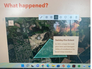
Despite not being certain of my career plans after graduation, following a GIS-related path is a solid option for me. To me, GIS is not much of a field in itself, but rather it is about what you do with it and what is that you seek to obtain from it. There are numerous GIS applications that one can use, and tons of considerations that the user has to think through. As a GIS user, you are in great control of what you want to prove and show the world, and if your interests have a geographical and spatial root, GIS might unlock hidden research possibilities you never thought existed in the first place. I am confident that having done this GIS experience will help me not only in physical geography and scientific situations (such as wildfires or suitable wind farm locations as studied in class), but it also in more human approaches related to crime data, socio-demographic matters and more. Having said that, you may find myself doing GIS work in the future, but nevertheless my Geography degree at The University of Manchester equipped me with versatile skills, which makes the future pleasantly unpredictable.
Therefore, I highly recommend doing an internship or placement. The more related to your degree, the better, but do not underestimate the transferable skills you can get from an opportunity seemingly irrelevant to your studies. You will be astonished by how useful it is to develop skills like time management, communication and teamworking, and going through a difficult work experience will build up your professional fortitude, which is a great ability to have when handling life kicks in your twenties. So the next time you see a job that you can imagine yourself doing, apply to it. Just apply!


0 Comments